
The Estate - Bevendean History Project

Parch Marks on Farm Green in BevendeanRon Porter
contacted the website to say that he has posted a couple of photographs
on the Bevendean Community Group Facebook page of the foundations of
some of the buildings that were originally on Farm Green, they are
shown up by the scorched grass.
Ron asks is anyone with a drone would be willing to take aerial photos to show exactly where the foundations are location in relation to other buildings & trees.
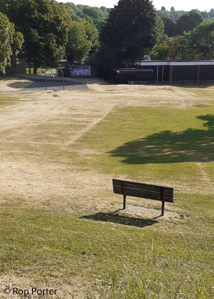
His photograph of the parch marks show the wall lines for the buildings which were used for the first church in Bevendean. As the building had been a barn on Lower Bevendean Farm, the church was known as the Barn Church and was dedicated on 8th October 1953 by the Bishop of Lewes.
Further information
There are some photographs of parch marks taken in 2013 in the photographs section. The link is ‘Photos of Bevendean 2013’.
On the Estates page there is a link to a geophysical survey conducted in October 2019 which also shows the existence of wall foundations below the surface.
Ron asks is anyone with a drone would be willing to take aerial photos to show exactly where the foundations are location in relation to other buildings & trees.
His photograph of the parch marks show the wall lines for the buildings which were used for the first church in Bevendean. As the building had been a barn on Lower Bevendean Farm, the church was known as the Barn Church and was dedicated on 8th October 1953 by the Bishop of Lewes.
Further information
There are some photographs of parch marks taken in 2013 in the photographs section. The link is ‘Photos of Bevendean 2013’.
On the Estates page there is a link to a geophysical survey conducted in October 2019 which also shows the existence of wall foundations below the surface.
bev_estate_story_034_news
