
The Estate - Bevendean History Project

Geophysical Survey of Farm Green in BevendeanIn October
2019, Brighton and Hove Archaeological Society on behalf of the
Bevendean History Group undertook a geophysical survey of Farm Green in
Bevendean. Farm Green is located to the south west of Bevendean Primary
School and houses the Farm Green playground which was recently
renovated.
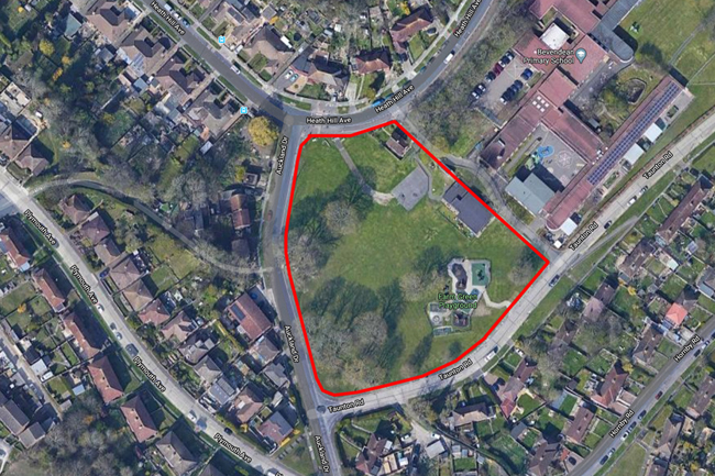
Fig 1 – map of Farm Green 2019 and location of resistivity survey © google
History of the site
The settlement of Bevendean was first mentioned in the Domesday Book of 1086 the Manor of ‘Bevedene’ known to be worth £6 and owned by William de Waranne. It is thought the ownership fell into the hands of the Folkington family after the death of De Waranne and in 1230 he gave the Monks of Lewes a plot of land in Bevendean lying beside his well with a right to draw water from it. In 1533 there is a reference to Bevynden Farm in a Will for John Levitt, dated 22 October. In 1639 Thomas Covert of Slaugham owned the farm.
Bevendean Farm continued into the post-medieval period, the settlement is shown on a Sussex map of 1819 (Fig 2).
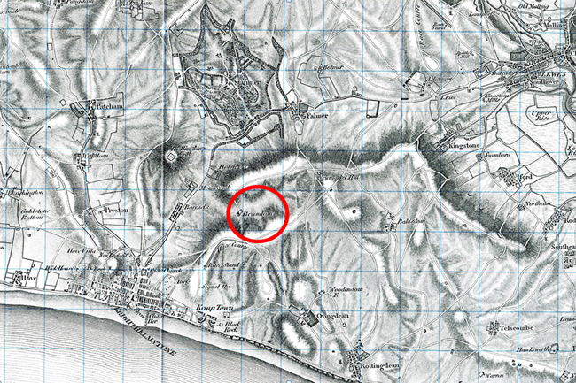
Fig 2 - 1819 Sussex map reproduced courtesy of East Sussex Record Office
From the late 19th century the farm was split between 7 different tenants and had a total area of about 691 acres with Upper Bevendean Farm having a sizable proportion of the land and some land going to Heath Hill Farm (Fig 3).

Fig 3 - 19th century map plotting the farms within the land of Bevendean – Lower Bevendean Farm indicated in red.
An enlarged view of Lower Bevendean Farm and its layout in 1873 is provided in Figure 4.
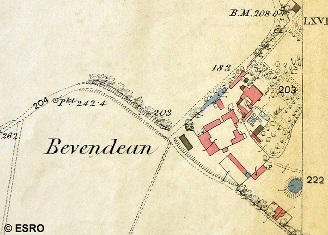
Fig 4 1873 Ordnance Survey Epoch 1 map of Lower Bevendean Farm reproduced by kind permission of East Sussex Record Office
In 1909 the owner was Steyning Beard and the farm was leased to Mr F. J. Allcorn. Brighton Corporation purchased the Lower Bevendean Farm in 1913, with an area of about 279 acres. The tenancy of Lower Bevendean Farm was relinquished in September 1942 by F. J. Allcorn when Brighton Corporation needed the land for houses and a new primary school. Most of the farm buildings were pulled down before 1959, but a plan of the site from the 1950’s shows the location of the buildings still remaining on what is now known as Farm Green (Fig 5). The Corn, Hay and Straw barn of 16th century date remained in use during the 1950’s as a church. In the 1970’s an order was raised for the demolition of the final buildings.
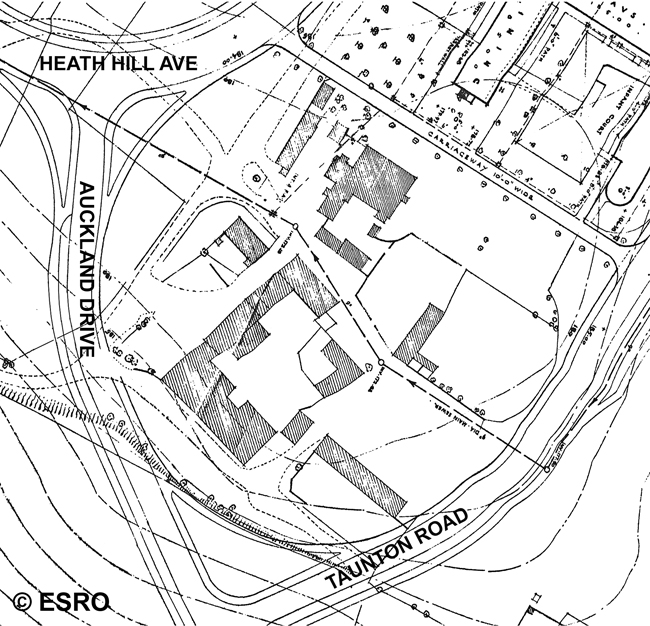
Fig 5 – 1950’s plan of the site East Sussex Record Office R/C 33/37 reproduced by kind permission of East Sussex Record Office
The Geophysical survey
Bevendean History Group (BHG) was keen to see what remains were still left at Farm Green after their demolition in the 1970’s. Whilst the buildings were demolished, it did not mean that all traces of the buildings were removed. Bevendean History Group approached Brighton and Hove Archaeological Society (BHAS) to see if they would undertake a geophysical survey which is a non-invasive scientific method used by archaeologists to understand what may be below the ground. The group were thrilled when BHAS agreed to undertake this project in October.
A date was agreed but the weather is an important factor to enable the survey to get a clear picture. Light rain can sometimes be useful to the results but heavy rain can cause saturation and provide unclear / false results. We were lucky enough that the rain did not spoil our fun on either of the two days the survey took place. A group of people from both BHG and BHAS took part in the survey and some of the local community also got involved. There was lots of interest on the days as to what was being done!
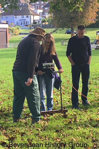
Photograph of Pete Tolhurst (BHAS) showing a member of the BHG and her husband how to do the survey.
The particular type of geophysical survey used was an electrical resistivity survey. This type of survey measures tiny variations in electrical resistance of the ground by sending small electric currents between sensors. Variations in electrical resistance of the ground can be caused by walls which might reduce the electrical current, or ditches for example which will increase the size of the electric current as they will hold slightly more water. After a few days of processing, BHAS were very excited to say that the survey results were a success and we could clearly see activity in the areas of the buildings we would expect.
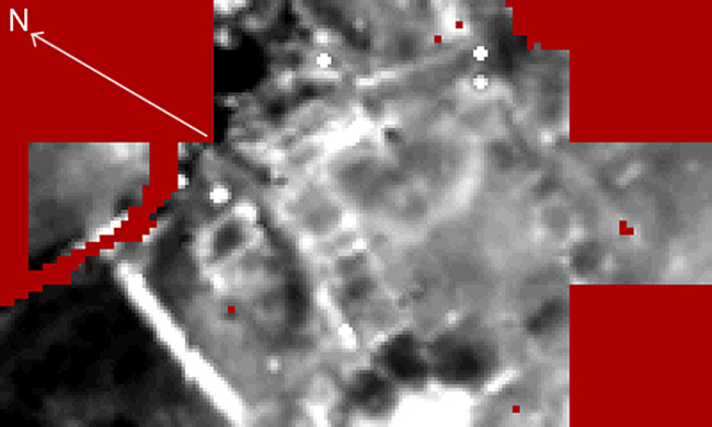
Fig 6 – results of geophysical survey undertaken in 2019
To the untrained eye this may not appear to show much but it does show a range of foundations which match some of the building plans from the 1950’s and signals the possibility of remains still surviving.
Next steps
In the future the BHG and BHAS would like to undertake an excavation on the site to ground truth some of these results, so watch this space. In the meantime it was lovely to undertake a community project alongside BHAS and enjoy some of the autumn sunshine we were very lucky to have!
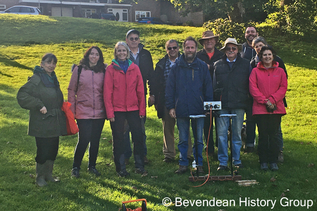
A picture of BHG and BHAS members at the end of the first day of surveying.
Fig 1 – map of Farm Green 2019 and location of resistivity survey © google
History of the site
The settlement of Bevendean was first mentioned in the Domesday Book of 1086 the Manor of ‘Bevedene’ known to be worth £6 and owned by William de Waranne. It is thought the ownership fell into the hands of the Folkington family after the death of De Waranne and in 1230 he gave the Monks of Lewes a plot of land in Bevendean lying beside his well with a right to draw water from it. In 1533 there is a reference to Bevynden Farm in a Will for John Levitt, dated 22 October. In 1639 Thomas Covert of Slaugham owned the farm.
Bevendean Farm continued into the post-medieval period, the settlement is shown on a Sussex map of 1819 (Fig 2).
Fig 2 - 1819 Sussex map reproduced courtesy of East Sussex Record Office
From the late 19th century the farm was split between 7 different tenants and had a total area of about 691 acres with Upper Bevendean Farm having a sizable proportion of the land and some land going to Heath Hill Farm (Fig 3).
Fig 3 - 19th century map plotting the farms within the land of Bevendean – Lower Bevendean Farm indicated in red.
An enlarged view of Lower Bevendean Farm and its layout in 1873 is provided in Figure 4.
Fig 4 1873 Ordnance Survey Epoch 1 map of Lower Bevendean Farm reproduced by kind permission of East Sussex Record Office
In 1909 the owner was Steyning Beard and the farm was leased to Mr F. J. Allcorn. Brighton Corporation purchased the Lower Bevendean Farm in 1913, with an area of about 279 acres. The tenancy of Lower Bevendean Farm was relinquished in September 1942 by F. J. Allcorn when Brighton Corporation needed the land for houses and a new primary school. Most of the farm buildings were pulled down before 1959, but a plan of the site from the 1950’s shows the location of the buildings still remaining on what is now known as Farm Green (Fig 5). The Corn, Hay and Straw barn of 16th century date remained in use during the 1950’s as a church. In the 1970’s an order was raised for the demolition of the final buildings.
Fig 5 – 1950’s plan of the site East Sussex Record Office R/C 33/37 reproduced by kind permission of East Sussex Record Office
The Geophysical survey
Bevendean History Group (BHG) was keen to see what remains were still left at Farm Green after their demolition in the 1970’s. Whilst the buildings were demolished, it did not mean that all traces of the buildings were removed. Bevendean History Group approached Brighton and Hove Archaeological Society (BHAS) to see if they would undertake a geophysical survey which is a non-invasive scientific method used by archaeologists to understand what may be below the ground. The group were thrilled when BHAS agreed to undertake this project in October.
A date was agreed but the weather is an important factor to enable the survey to get a clear picture. Light rain can sometimes be useful to the results but heavy rain can cause saturation and provide unclear / false results. We were lucky enough that the rain did not spoil our fun on either of the two days the survey took place. A group of people from both BHG and BHAS took part in the survey and some of the local community also got involved. There was lots of interest on the days as to what was being done!
The particular type of geophysical survey used was an electrical resistivity survey. This type of survey measures tiny variations in electrical resistance of the ground by sending small electric currents between sensors. Variations in electrical resistance of the ground can be caused by walls which might reduce the electrical current, or ditches for example which will increase the size of the electric current as they will hold slightly more water. After a few days of processing, BHAS were very excited to say that the survey results were a success and we could clearly see activity in the areas of the buildings we would expect.
Fig 6 – results of geophysical survey undertaken in 2019
To the untrained eye this may not appear to show much but it does show a range of foundations which match some of the building plans from the 1950’s and signals the possibility of remains still surviving.
Next steps
In the future the BHG and BHAS would like to undertake an excavation on the site to ground truth some of these results, so watch this space. In the meantime it was lovely to undertake a community project alongside BHAS and enjoy some of the autumn sunshine we were very lucky to have!
A picture of BHG and BHAS members at the end of the first day of surveying.
More photographs of the surveying
