
Bevendean History Project
Parish of FalmerChanges to Falmer Parish Boundaries from 1928
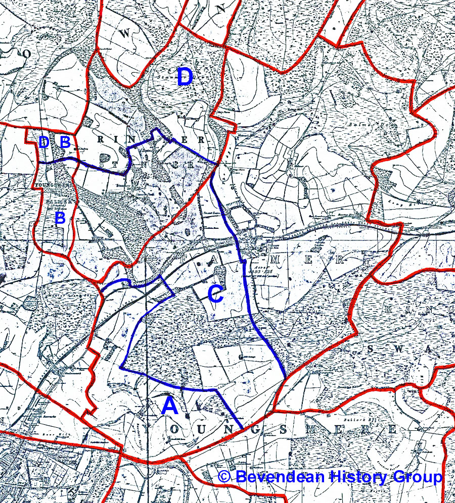
The solid red lines are the ancient parish boundaries.
On April 1, 1928 Brighton annexed 781 acres of Falmer (area A)
including the area around East and North Moulsecoomb, Bevendean and
Falmer School.
In 1934 Falmer lost the detached area B known as Patchway around Old Boat Corner to Stanmer.
On April 1, 1952 a further 1,028 acres was annexed by Brighton (area C) including the lower part of Stanmer Park, the sites of Sussex University and the Polytechnic, later Brighton University, campuses and a large area of Downland on Falmer Hill. At the same time Falmer by then in Chailey Rural District absorbed area D from Stanmer parish.
Falmer is now a parish of 3,122 acres under Lewes District Council.

The 1939 map shows how Brighton had eaten into the neighbouring administrative areas.
Ecclesiastical Parish of Falmer
In ancient times civil and ecclesiastical parishes had the same boundaries although the term ecclesiastical parishes did not come into use until after 1894.
The boundaries of the ecclesiastical parish of Falmer did not change until 1931 when the parish of St Andrew, Moulsecoomb was created from parts of the parishes of Patcham and Falmer.
The areas lost from Falmer parish included Moulsecoomb, Coldean and Lower Bevendean Farm and the land which now forms the Lower Bevendean estate.
In 1952 part of the parish of Falmer in the Ditchling road area was transferred to the parish of St Matthias.
On the 30th December 1975 an Order was published for creating a new benefice and parish of Stanmer with Falmer out of part of the parish of Stanmer-with-Falmer and Moulsecoomb, and altering the name of that benefice and parish to that of Moulsecoomb, in the diocese of Chichester.
On 6th August 1981 an order was published in the London Gazette establishing a team ministry for the area of the benefice of Moulsecoomb, in the diocese of Chichester at which time it appears that Stanmer-with-Falmer became a separate parish again.
In 2015 the ecclesiastical parish is still called the parish of Stanmer-with-Falmer although the church at Stanmer has been declared redundant and closed on 31 March 2008.
Ecclesiastical Parish Maps
